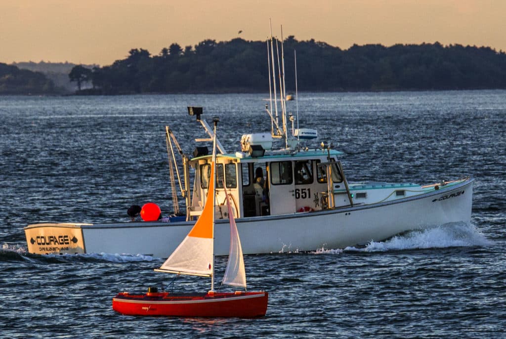
A strong southerly breeze blew over the sleepy seaside village of Port Townsend, Washington, on the morning of June 23, 2016, just in time for the start of the second annual Race to Alaska (R2AK), a “human-powered” contest that takes racers to Ketchikan by way of Victoria, British Columbia, and the inside passage separating Vancouver Island from the mainland. While other teams synced their starts with the race committee’s gunshot, the Navocean team opted to let the fleet go before placing Nav2, their autonomous surface vehicle, into the still-ebbing tide. Nav2 immediately started fetching her waypoints while her creators followed astern in a RIB, hoping that the wind would hold and that their tidy ASV would beat the next tide cycle.
As do many great sailing-related ventures, the Navocean project began over a bottle of wine. The year was 2000, and Ethan Arutunian and Scott Duncan, two friends who met at Whitman College, were pondering a model sailboat, wondering how far such a craft could travel on the open ocean, sans active remote control or human input. The idea of building an autonomous sailboat sounded better and better as the wine bottle emptied, and later that year, Arutunian, a talented software developer, and Duncan, a skilled boatbuilder, launched a rough remote-controlled prototype, dubbed MiniNav, which the team used to test hull shape and sail configurations.
Beyond their mutual interest in the design challenge of building an ASV, Arutunian and Duncan also share a strong interest in marine science. Arutunian had spent time at sea monitoring sperm whales off of Norway, and had sailed with Duncan from Maine to the Caribbean to make passive acoustic recordings of these charismatic creatures. He had experienced firsthand the physical and psychological ravages of seasickness while trying to write computer code belowdecks in a heaving seaway. In addition, he understood the pecuniary limitations of manned research vessels. “It’s so expensive today to send a team on a research boat and deploy your instrument for a week, once a year, to get that little snapshot of data,” says Arutunian, who adds that just chartering a research vessel for a scientific expedition can exceed $50,000 per day.
This dual interest in ASV technology and scientific research ultimately gave the team their design brief. “The overall concept was to build an advanced form of an ocean buoy,” says Duncan, Navocean’s chief designer. Instead of focusing on high-speed sailing performance (Nav2‘s top speed is 3 to 4 knots), the team focused on stability, operational silence, and the ability to negotiate a wide range of offshore conditions.
Like many startup ventures, Navocean experienced some starts and stops as Arutunian and Duncan balanced their professional and family lives with their nascent company. Thanks to a small grant from the Maine Technology Institute in 2004, the pair built a second-generation boat in 2004 that incorporated a specialized computer, a more developed hull form, and more advanced autonomous-sailing capabilities, but Arutunian and Duncan still were not satisfied. Some years passed, but in this case, the extra time brought with it significant advances in technology, such as miniaturized sensors and touchscreen-enabled mobile devices, as well as app-based software and graphically rich and intuitive user interfaces. Couple this with the advent of the Automatic Identification System and new scientific instruments, and the team had some powerful new tools at their disposal.
While the original MiniNav showed promise, Arutunian knew that future vessels would have to be fully autonomous and capable of carrying a sizable scientific payload to attract the attention of scientists and research universities. While the team’s second-generation ASV marked an evolution over its prototype, a purchase order from the University of Maine in 2014 allowed Arutunian and Duncan to build a larger, third-generation vessel, Nav3, with sensors for data collection as part of NOAA’s Northeast Regional Association of Coastal Ocean Observing Systems.
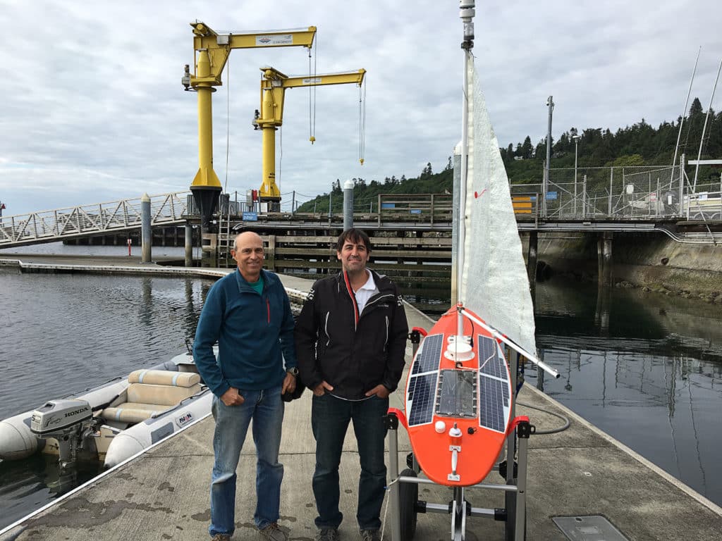
In 2015, Arutunian and Duncan designed and built a brand-new fourth-generation ASV, which they named Nav2 in reference to its 2-meter LOA. They set out to use the 2016 R2AK, which had swept up the sailing community with its media-friendly 2015 debut, to demonstrate its capabilities on an international stage. While Duncan tackled the hull form, appendages and sail plan, Arutunian wrote all of the vessel-operations software and developed an app for controlling the ASV that can be run on smartphones, tablets or computers, giving the team a huge amount of operational flexibility. He also custom-built the ASV’s “brain,” which consists of a computer, server, scientific instrumentation and communications infrastructure. This equipment is contained in a watertight box — complete with temperature and moisture sensors — inside the hull, which is also watertight.
To navigate and sail, Nav2 carries a GPS receiver, Airmar wind sensor, listen-only AIS receiver, electronic compass and pitch-heading-roll sensor, which is used to make compass corrections. An autopilot maintains course, an unstayed carbon-fiber mast supports the mainsail-and-jib sail plan, and a small, anti-jamming winch controls Nav2’s two-line sheeting system. In case Nav2 gets stuck in irons or is dealt a windless day, the boat is fitted with a small electric thruster, which the team had to remove to comply with the R2AK’s rules, but which will be aboard any ASVs deployed for scientific research.
Power is a precious commodity on any boat, and Nav2 runs on two lithium iron phosphate batteries that provide 40 amp-hours, as well as on four deck-mounted solar panels (rated to 35 watts in full sun) that trickle-charge the house batteries. Arutunian says Nav2 uses just half an amp-hour per hour to operate under normal conditions, giving it an 80-hour range without any topping off; this range can be increased by decreasing sample and reporting rates.
Nav2 is governed by a series of algorithms that allow the boat to navigate. It’s important to remember that just like an autopilot, Nav2 can’t anticipate oncoming puffs or wave sets, but instead reacts to changes in conditions. The algorithms rely on a series of performance notches that trigger the vessel to adjust trim. For example, if the apparent-wind angle is 120 degrees, Nav2‘s program tells it to pay out a set amount of sheet; if the angle decreases to 90 degrees, Arutunian’s code automatically instructs the winch to pull in the sails by a designated amount. “It will trim to every sail angle,” says Arutunian, “and it has the smarts to know when to tack upwind.”
Nav2 is also capable of navigating shallow waters — a challenge for the larger, more complex ASVs and underwater drones currently used to gather data. To meet the team’s scientific goals, Nav2 is designed to carry 25 pounds of scientific instruments, with bursts of up to 50 watts of onboard power available. Nav2 features transducer housings for an acoustic Doppler current profiler, which allows scientists to quantify how quickly water is moving across a given water column; a conductivity and temperature sensor, which is used to study physical properties of ocean water, including water salinity and heat; and a fluorometer, which is used to measure the intensity of fluorescence (i.e., the emission of light from algae or other ocean flora).
Additionally, Nav2 can deploy towed sensors, and it can be fitted with bespoke instrumentation and sensors.
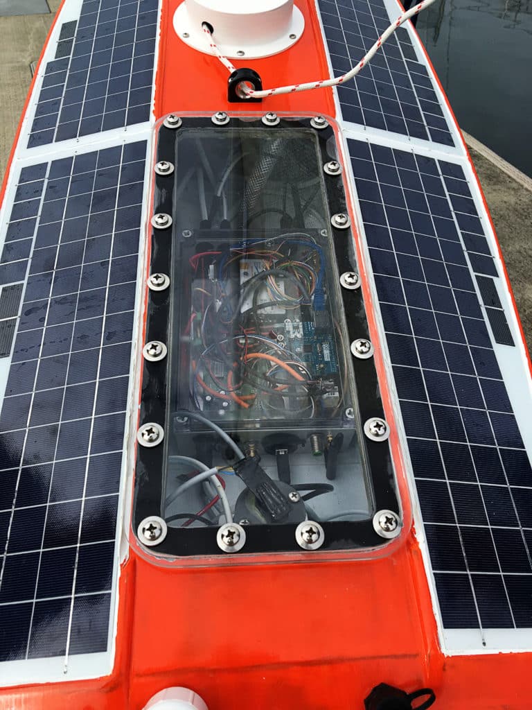
Not surprisingly, Nav2 carries a sophisticated communications system, which it uses to upload data, receive navigation instructions (such as new waypoints or data-sampling patterns), and report on any AIS crossing situations. Arutunian points to this communication system — which consists of Wi-Fi, a cellular modem and an Iridium modem — as the project’s most time-consuming work. Because Nav2 will upload data via an expensive Iridium connection when it’s offshore, part of Arutunian’s challenge was to minimize the volume of data that needs to be transmitted. He achieved this by adding data compression to the system. As a result, each of Nav2‘s reports contains a mere 150 bytes of burst data.
Shoreside, Nav2 is controlled by Arutunian’s custom app, which allows users to set new waypoints, manually trim the sails, and monitor Nav2‘s various navigation and scientific instruments. While almost all of the vessel’s operations are autonomous, the ASV is designed to alert the Navocean team of any threatening AIS crossing situations via email and SMS text message; these are manually negotiated — via the app — to ensure that humans are highly involved with Nav2‘s collision-avoidance scheme.
Unfortunately, despite plenty of eyes being fixated on Nav2 during her R2AK attempt, the strong southerly breeze died before the ASV reached the Strait of Juan de Fuca. When a powerful 10-hour flood tide began pressing her back toward Port Townsend, the Navocean team made the call to abandon racing, as mathematically there was no way that Nav2 could reach Victoria within the mandated 36-hour window.
While the Navocean team wasn’t thrilled with this tidal setback, the success of an identical ASV, currently searching for harmful algae blooms off the Florida coast, more than satisfied their proof-of-concept testing. The team plans to market their autonomous vehicles to universities, scientists and research groups at a price point between $70,000 and $100,000 (depending on instrumentation). Here the Navocean team believes they have another advantage, as many other ASVs on the market can cost north of $250,000. To further lower the barrier to entry, they are also considering rental schemes to make the technology available to students and researchers who have more modest funding. “These things have the potential to change the whole research-gathering world,” says Arutunian.
Additionally, the Navocean team foresees possible government and military interest in tiny, near-silent ASVs that can patrol otherwise desolate waters for up to six months at a time without maintenance. “One of the potential uses of these drones is that we can gather AIS data from places that no one is getting it right now,” says Stuart Lochner, who joined the Navocean team in 2015 to help with sales and mission support. “All that data is being sent to us; we could then provide it to servers like MarineTraffic. So this is potentially a data portal, or a water-based repeater, for places where they don’t get AIS traffic right now. The military and U.S. Coast Guard are the kind of people who like to know what kind of traffic is out there.”
So while Nav2 may never win an offshore sailboat race, there’s little question that this multipurpose ASV represents a huge advancement. With Nav2‘s ability to autonomously sail from one area of study to the next, negotiate shallow depths, and transmit highly compressed data with its (relatively) moderate price tag, odds are good that a project that began with a bottle of wine, a simple model sailboat, and a dream could have far-reaching impacts on the scientific community.
David Schmidt is CW’s electronics editor.


