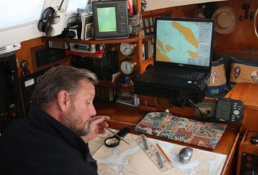
Alvah looks both into the past and the future as he plots a course across the Pacific.
The Pacific Ocean covers 64 million square miles of the Earth. To put that into context, the continental United States would fit within its expanse 20 times with room to spare. Establishing and charting our route from Washington State to New Zealand across that immensity was our task this week.
It was difficult for two reasons. First, much like a modern electric bill, charting programs with differing scales, erratic coverage, inexplicable insets, and irrational numbering systems seem specifically designed to confound even the brightest of sailors. (Not to suggest that I am one.) Secondly, a route that includes both Hawaii and Fiji (new destinations for me) sensibly passes through American and Western Samoa. Based on our past visits there, anyone would be happy to return. But this would mean missing Tuvalu, the wild west of underwater adventures.
So, we had some tough choices to make, and once we agreed on a viable route, I set to work charting our course. While I once declared that I would give up my sextant when they pried it from my cold, dead fingers, I must admit that there is no going back from the accuracy and ease of the GPS, especially when superimposed on interactive electronic charting programs. I now have two charting programs loaded onto two computers that are able to interface with two GPS units.
Still, as old fashioned as it may seem, I wouldn’t think of casting our lines without proper paper charts leading our way. This, of course, is for reasons of reliability and redundancy. But also, much like preferring the tactile quality of the printed book to a computer screen, I like the feel of a nautical chart. It takes me back to a world as wide as it once was. It evokes a sense of wonder and an urge to wander that no cold screen can.
Some of the old charts we pored over represented amazing works of cartography. Chart #440 – Fiji Islands – Eastern Group is based on a survey conducted by Lieutenant W.U. Moore of the Royal Navy from 1878-1882. Just in case we were worried about the currency of the information, a note assured us that the chart was updated as recently as 1895.
Every old paper chart, swapped from cruiser to cruiser over the years, carries on its face the scars of hard travel. Like animal tracks in the snow, faint pencil lines leave a trail now grown cold. But to the observant, they still have a story to tell. I found clues to the personalities and experiences of these anonymous sailors in the positions plotted and notations made.
One set of navigational markings I encountered left no doubt that this skipper was a meticulous and methodical man. His ship’s progress is crisply labeled in correct nautical fashion. His heading, marked as true, compass, or magnetic, is noted in three numerals above and parallel to the course line. Speed is always noted under the line, expressed in two digits with a decimal. Time, correctly expressed in four digits using the 24-hour clock and identified as GMT or local, is recorded perpendicular to the course line. If he missed a single noon sight you can assume the skies were cloudy on that day.
A different owner of that same chart was obviously much more laid back. In fact the irregularity of his fixes are somewhat alarming. Days go by without so much as an estimated position being plotted. Then he suddenly seems to wake up too near to land, and frantic calculations follow – as if to say, “Like, wow man, Tonga. Like, already.”
One vessel, obviously savoring their cruise, lingered in numerous outlying Polynesian islands. Another plot shows Red pencil flying across this section of the Pacific, the navigator obviously in a hurry to be somewhere else.
I wonder about the confidence of the navigator that made his marks in ink. Would or could he ever admit to a mistake? I say ‘he’ because I felt I could detect when the navigator was female. And do all those eraser marks indicate a novice navigator, or are they just the deep fatigue of too many gales? Based on the wide angles of their tacks this vessel was either a square-rigger or needed to tune its rig.
From the daily plots I can calculate the speeds of passages past. Somehow this triggers my competitive nature, as I find myself trying to beat the noon-to-noon run of a phantom rival.
Mostly the celestial fixes are based on noon sites, but on occasion I find the tight triangle of selected star shots. I feel a kindred spirit with this navigator, for the evening shot of the stars was always my favorite moment of the day.
Coffee stains and cigarette burns – did they run out in the middle of the ocean? That might explain the abrupt course change to Hawaii. With time I believe I could finesse out more detail from even these scant markings. But one thing I know already-each line represents some sailor pursuing his or her dream across our mightiest of oceans. And timelines aside, these lines bind us all together as sailors on the same sea.

