Jimmy Cornells South American Vacation
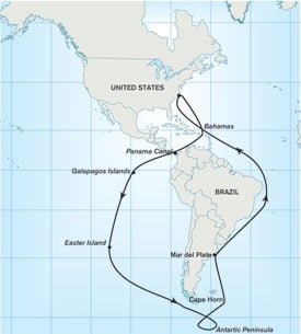
North American Sailors with a sound boat, a few months time, and a desire for a voyage to remember need look no farther than their own hemisphere to find an ambitious get-away: a complete circumnavigation of the South American continent, with a possible detour to Antarctica.
Because more favorable weather and wind conditions will be encountered by sailing around South America in a counter-clockwise direction, East and Gulf Coast cruisers can look forward to a trip through the Panama Canal in the early stages of the journey. The voyage can be accomplished in the opposite direction, but it would be much harder. I know this from personal experience from my second voyage to Antarctica. Sailing south via Brazil and Argentina presented no great problems, but sailing north through the Chilean canals against the prevailing northwest winds was hard, hence my advice to go the other way.
The easiest route south from the East Coast of the United States is via the Outer Bahamas and Windward Passage. From there a direct course can be sailed across the Caribbean Sea for Colon at the entrance to the Panama Canal by keeping well to windward of the various reefs and islets south of Jamaica. If time permits, a detour to the San Blas Islands is well worth the effort, and can be easily accomplished before the canal transit. The best time to start this voyage is late spring, just before the start of hurricane season in the Caribbean. Such timing will allow enough time to reach Southern Chile at the optimum time, from October to January.
Once in the Pacific Ocean, there are two main options for the southbound route from Panama: a detour via the Gaapagos Islands, or a track that follows the coast of South America. If the latter option is chosen, the route should stay far enough from the Colombian coast to keep clear of any dangers. This first leg should be sailed non-stop to Ecuador where there is a good marina at La Libertad, the Puerto Lucia Yacht Club. This is a convenient place to stop for fuel and provisions, and is also a safe place to leave the boat to visit the interior, whether the Andes or a corner of Amazonia. The route then continues south along the coasts of Peru and Chile, with several ports on the way where one can stop for fuel and provisions. Light south east winds, the contrary Humboldt Current and the long distances to be covered will probably make this a slow leg on which a reliable engine and plenty of fuel will be of utmost importance.
The alternative is to seek better winds offshore, which will mean covering a lot more miles but being able to sail most of the way. One further advantage of such an offshore route is the opportunity to call at two highly attractive destinations: the Galapagos and Easter Island. The winds between Panama and the Galapagos, as well as to mainland Ecuador, are mostly northerly at the start, but becoming light and variable as one moves south.
Formalities in the Galapagos Islands have been greatly simplified and cruising boats are now welcome to stop at one of the two main ports of entry: Puerto Baquerizo Moreno on Isla San Cristobal and Puerto Ayora on Isla Santa Cruz. Although it is possible to obtain a permit to cruise the various islands, this is an extremely costly exercise and the boat must be accompanied by a licensed guide. The alternative is to base your boat in one of the above mentioned ports and join one of the local excursion boats on day trips to the other islands.
On the next leg, from the Galapagos to Easter Island, the prevailing winds will be from the south east, which means that much of this leg will be close to the wind. However, getting to the island of the giant statues is well worth the effort, as there are few more interesting places in the entire world. The best anchorage is off the main settlement at Hanga Roa, on the island’s west coast. Like with everything else in life, there is a price to be paid for this detour: There is simply no easy way to sail from Easter Island to mainland Chile. Although one may be able to motor through the Pacific high, probably the better alternative is to head south in search of prevailing westerly winds, which will probably be reached somewhere south of latitude 32 degrees south. From there the course should be set for the Chilean coast, with a landfall in the area of the Canal de Chacao, north of Isla Grande De Chiloe. This narrow body of water is swept by strong tides and leads to the marina at Puerto Montt, which is the best place to get charts, provisions and local information on Southern Chile.
Once the Gulf of Penas is reached south of the Isla Grande De Chiloe, one can sail inshore and in sheltered waters all the way to Islas Hornos at the southern extremity of the continent. This vast area, which stretches for well over 1,000 miles, is a maze of fiords, narrow passages, ancient forests, snow-clad mountains and mighty glaciers. Solitude is absolute.
Weather conditions in summer (October to January) are relatively good and the prevailing winds are from the northwest, hence my recommendation to cruise this area from north to south. Stronger winds with violent gusts (the infamous willawas) become more frequent as one moves south so one should be prepared for these sudden blasts both when sailing and at anchor. Puerto Eden, about halfway between Chiloe and Cape Horn is the only place to get fuel or provisions, so self-sufficiency is an absolute necessity in this part of the world.
This spectacular route reaches its conclusion at the Canal Beagle and a choice of ports; the larger, better endowed Argentine port of Ushuaia, or the remote Chilean military base of Puerto Williams. The former has all essential facilities, including an airport with direct flights to Buenos Aires.
Puerto Williams is a favorite port of call for boats heading for either Cape Horn or Antarctica, both of which fall under the jurisdiction of Chile, so permission to head south needs to be requested here. Those who choose to skip Antartica and who have reached the southernmost point of their voyage, move on east via the Canal Beagle, leaving Isla de los Estados (Staten Island) to port and then turning north towards the Falkland Islands.
Those undaunted by a crossing of the Drake Passage, meanwhile, can keep their bows pointing south towards the Antarctic Peninsula. Crossing the 600-mile-wide Drake Passage in a well-found boat during the optimum summer time (December to February) should present no problem. Ideally one should set off immediately after the passing of a low when the winds will veer from northwest to northeast. The risk of encountering icebergs during the offshore passage is not very high in summer, but a good lookout should be kept nonetheless.
A good starting point for a cruise inside the sheltered waters off the western side of the Antarctic Peninsula is Deception Island. From there the route leads in a generally southwest direction with a choice of good anchorages. The scenery is quite breath-taking and there is lots of wildlife: large penguin colonies, pods of courting humpback whales, and various species of seals, including the enormous elephant seals. Weather conditions in the optimum summer months are quite benign, and temperatures rarely fall below freezing.
When it’s time to head north again, a good departure point is in the area of the Melchior Islands, from where the open sea is easily reached. Getting back to Cape Horn against the prevailing westerly winds and east-setting current is not easy, so if one wants to visit Horn Island, where it’s possible to land, it’s better to do this before setting off for Antarctica. Then the return voyage will be much easier as a direct course can be set for the Falklands, staying east of both Cape Horn and Staten Island.
Stanley is the main settlement on the remote Falklands, and makes a good port of call for boats heading north. The Argentine coast south of the port of Mar del Plata has few attractions and is best passed well to seaward. Mar del Plata is a busy seaside resort with several yacht clubs that welcome visitors. The homebound route continues parallel to the Brazilian coast with plenty of landfall and cruising opportunities. Going north from the Falklands the prevailing winds will be westerly with a favorable north-setting current. Along the Brazilian coast the prevailing winds up to April are northeast, becoming southeast in May, so this section should not be attempted too early in the season. Once the equator is reached the winds become easterly and there is also a strong northwest-setting current that ensures a fast passage to the Lesser Antilles. As the Eastern Caribbean will be reached near the end of the winter season, there will be little time to linger. A good pace needs to be maintained to arrive back in the States the before the onset of the new hurricane season in June.
The total distance, including the detours to Easter Island and Antarctica, is 16,800 miles, though you can shave 3,000 miles off by skipping these visits. With good planning and careful preparation either option can be accomplished in the 12 months that have been allowed for the voyage.
About the Author
Jimmy Cornell has sailed to Antarctica twice, in 1996 and 1999. In the last 35 years he has sailed over 200,000 miles in his three different Aventuras.
In the October 2006 issue of Cruising World, Cornell plots two more modest cruises, one a North Atlantic circle, the other a voyage heading south through the Caribbean.

