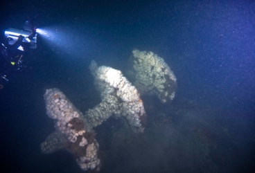
More than 153 years after it was lost in a violent collision at sea, government and university maritime archaeologists have identified the wreck of the ship Robert J. Walker, a steamer that served in the U.S. Coast Survey, a predecessor agency of NOAA.
The Walker, while now largely forgotten, served a vital role as a survey ship, charting the Gulf Coast ‒ including Mobile Bay and the Florida Keys ‒ in the decade before the Civil War. It also conducted early work plotting the movement of the Gulf Stream along the Atlantic Coast.
Twenty sailors died when the Walker sank in rough seas in the early morning hours of June 21, 1860, 10 miles off Absecon Inlet on the New Jersey coast. The crew had finished its latest surveys in the Gulf of Mexico and was sailing to New York when the Walker was hit by a commercial schooner off New Jersey. The side-wheel steamer, carrying 66 crewmembers, sank within 30 minutes. The sinking was the largest single loss of life in the history of the Coast Survey and its successor agency, NOAA.
“Before this identification was made, the wreck was just an anonymous symbol on navigation charts,” said Rear Admiral Gerd Glang, director of NOAA’s Office of Coast Survey. “Now, we can truly honor the 20 members of the crew and their final resting place. It will mark a profound sacrifice by the men who served during a remarkable time in our history.”
Built in 1847, the Walker was one of the U.S. government’s first iron-hulled steamers, and was intended for the U.S. Revenue Service, the predecessor of the United States Coast Guard. Instead, the Walker and some of its sister steamers were sent to the U.S. Coast Survey.
Admiral Robert J. Papp, commandant of the Coast Guard, said that Walker represented the transition from sail to steam for government vessels, “reflecting the enduring need of the United States to harness the power of new technology to promote its maritime interests.”
“Coast Guardsmen are always saddened by the loss of life at sea and especially so when those lost were working to make the lives of other mariners safer by charting the waters of the United States,” Papp said.
The U.S. Coast Survey is NOAA’s oldest predecessor organization, established by President Thomas Jefferson in 1807 to survey the coast and produce the nation’s nautical charts. In 1860, as the Civil War approached, the Coast Survey redoubled efforts to produce surveys of harbors strategically important to the war effort along the Gulf and Atlantic coasts.
The New York Herald, in reporting the Walker‘s loss on June 23, 1860, noted that a “heavy sea was running, and many of the men were doubtless washed off the spars and drowned from the mere exhaustion of holding on, while others were killed or stunned on rising to the surface by concussion with spars and other parts of the wreck.”
The Walker wreck site initially was discovered in the 1970s by a commercial fisherman. The wreck’s identity has been a mystery despite being regularly explored by divers. Resting 85 feet underwater, the vessel’s identity was confirmed in June as part of a private-public collaboration that included research provided by New Jersey wreck divers; Joyce Steinmetz, a maritime archaeology student at East Carolina University; and retired NOAA Corps Capt. Albert Theberge, chief of reference for the NOAA Central Library.
While in the area to conduct hydrographic surveys after Hurricane Sandy for navigation safety, NOAA Ship Thomas Jefferson sailed to the wreck site and deployed its multibeam and sidescan sonar systems. Hydrographers searched likely locations based on analysis of historical research by Vitad Pradith, a physical scientist with NOAA’s Office of Coast Survey.
A NOAA Maritime Heritage diving team, on a separate Hurricane Sandy-related mission in the area, was able to positively identify the Walker. Key clues were the size and layout of the iron-hulled wreck, and its unique engines, rectangular portholes, and the location of the ship, which was found still pointing toward the Absecon lighthouse, the final destination of a desperate crew on a sinking vessel. “The identification of Walker is a result of excellent collaboration with the local community,” said James P. Delgado, director of maritime heritage for NOAA’s Office of National Marine Sanctuaries. “We look forward to working with our local partners to share Walker‘s story with the public in a manner that both promotes educational dive tourism and protects this nationally significant wreck and gravesite.”
NOAA’s intent is not to make the wreck a sanctuary or limit diving, but to work with New Jersey’s wreck diving community to better understand the wreck and the stories it can tell.
“We want to enhance the dive experience and support the dive industry with enhanced access to this wreck,” Delgado said. “New Jersey is home to some of the most accomplished wreck divers who not only understand history and wrecks, but who have also been in the forefront of wreck exploration. We look forward to working with them on the Walker.”
NOAA’s Office of Coast Survey is the nation’s nautical chartmaker. Coast Survey updates charts, surveys the coastal seafloor, responds to maritime emergencies, and searches for underwater obstructions that pose a danger to navigation. Follow Coast Survey on Twitter @nauticalcharts and check out the NOAA Coast Survey blog at for more in-depth coverage of surveying and charting.
NOAA’s Office of National Marine Sanctuaries serves as trustee for a system of 14 marine protected areas, encompassing more than 170,000 square miles of America’s ocean and Great Lakes waters. Through active research, management, and public engagement, national marine sanctuaries sustain healthy environments that are the foundation for thriving communities and stable economies. Follow Sanctuaries on Facebook and on Twitter @sanctuaries.
NOAA’s mission is to understand and predict changes in the Earth’s environment, from the depths of the ocean to the surface of the sun, and to conserve and manage our coastal and marine resources. Join us on Facebook, Twitter and our other social media channels.

