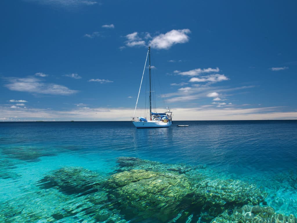
Each year cruisers set out across the Pacific in search of sparkling lagoons, white sandy beaches and colorful coral. Unfortunately, the many atolls that are scattered throughout this region tend to hide their hazards, which can lead to the dream ending in a nightmare if boat meets reef. Some crews underestimate tricky lagoon passes or end up trapped in anchorages on a lee shore after wind shifts. So, is it safer to give those turquoise atolls a wide berth? Absolutely not—it just takes some preparation, caution, and a good dose of common sense to minimize the risk and live the dream of the South Seas without a nasty awakening.
Lagoon Passes
Coral reefs grow in tropical waters, frequently around volcanic islands. The cones of these volcanoes sink back into the sea over millions of years, while the coral keeps growing. In the end, only a reef ring with sandbanks and low motus (the Polynesian word for island) remains around a lagoon. Many reef rings are completely closed and therefore less interesting for sailboats, but others feature passes that allow entry into the protected lagoon.
Three years ago, we approached our very first reef pass in Tahanea, in the Tuamotu Archipelago of French Polynesia. After reading horror stories about strong currents, standing waves that threaten to broach the boat, and eddies ready to twirl the unexpecting helmsperson toward deadly rocks, we felt more than just a bit nervous. We were almost disappointed when the broad pass lay quite unspectacularly ahead at slack water without showing any of the expected phenomena. Since then we have spent three seasons in the Tuamotu and Society Islands of French Polynesia, explored numerous atolls, and managed to enter through the infamous passes of Maupiti, which are negotiable only in calm conditions, and Maupihaa, which is less than 200 feet wide. Still, a certain tension remains whenever we approach an unknown atoll.
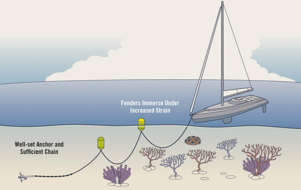
Coral-Friendly Anchoring with a Floated Chain
In advance, we compare electronic charts and satellite images to check for offsets. Upon arrival, we take our time, watch out for signs of currents, and tack up and down near the pass waiting for slack water. Steep, short waves and eddies outside the pass show that the current is still outgoing (especially noticeable when the wind is against the current), while the same conditions inside the lagoon indicate an incoming current. Tide tables are often unreliable, and the times of slack water are influenced by many factors. During and after a period of strong winds and/or high swell, the water level inside lagoons is generally higher and the outgoing current stronger, and it might persist even during the rising tide. It is therefore not advisable to attempt tricky passes in such conditions. Crews on a tight schedule with planes to catch or guests waiting are of course tempted to sail despite adverse circumstances, but it saves nerves and adrenaline to patiently wait for benign weather when hopping between atolls.
Lagoon Navigation
Once through the pass, the harsh ocean conditions remain outside, but you still have not necessarily reached a safe harbor. Wind and sea can still be rough inside the lagoon. Atolls stretch over many miles, and the fetch over such distances is more than a cruising yacht can comfortably (or safely) weather when anchored on the lee shore. So quite often it is necessary to cross the lagoon to find a safe anchorage.
Many atolls are poorly charted, if they’re charted at all. Sometimes charts give the illusion of detailed information, which then turns out to be offset, incomplete or utterly wrong. We rely on eyeball navigation with a lookout on the bow. It is best to explore unknown areas on clear days with the sun high up in the sky, and when coral heads (frequently called bommies) gleam out from afar in the dark blue of the lagoon. Polarized sunglasses filter away reflections and improve visibility.
When the sun is low in the sky, it is impossible to distinguish reefs under the glittering surface of the sea. On days with white clouds like cumulus or a high-altitude haze, visibility is also impaired. When rain clouds darken the sky, reefs can be clearly seen, but as soon as it starts pouring down, visibility above and below the surface goes down to zero.
In murky water, such as when the lagoon is churned up due to strong winds or a high swell breaking over the reef, it is also difficult to spot bommies. We therefore take advantage of sunny days to explore the lagoon and find anchorages for different wind directions, marking dangerous coral heads near the route on the chart plotter. In case of a sudden wind shift, we can always cross over to the safe side of the atoll, even during squalls. When planning routes, we work extensively with satellite images to get the big picture of the location, but also to find promising anchoring spots.
Anchoring in the Lagoon
In calm conditions, any anchorage will do, but 15 knots of wind are already enough to raise an uncomfortable chop across the lagoon. Anchorages along the reef shelf on the windward side of the atoll are protected from waves, but to get out of the wind, you have to anchor rather close to a motu.
Sometimes reefs and sandbanks form natural harbors or at least breakwaters inside lagoons. Such shapes can be seen clearly on satellite pictures, and anchorages behind coral formations are of course particularly pretty and great for snorkeling. Unfortunately, waves can typically make it over such reefs at high water, so it can get quite bouncy.
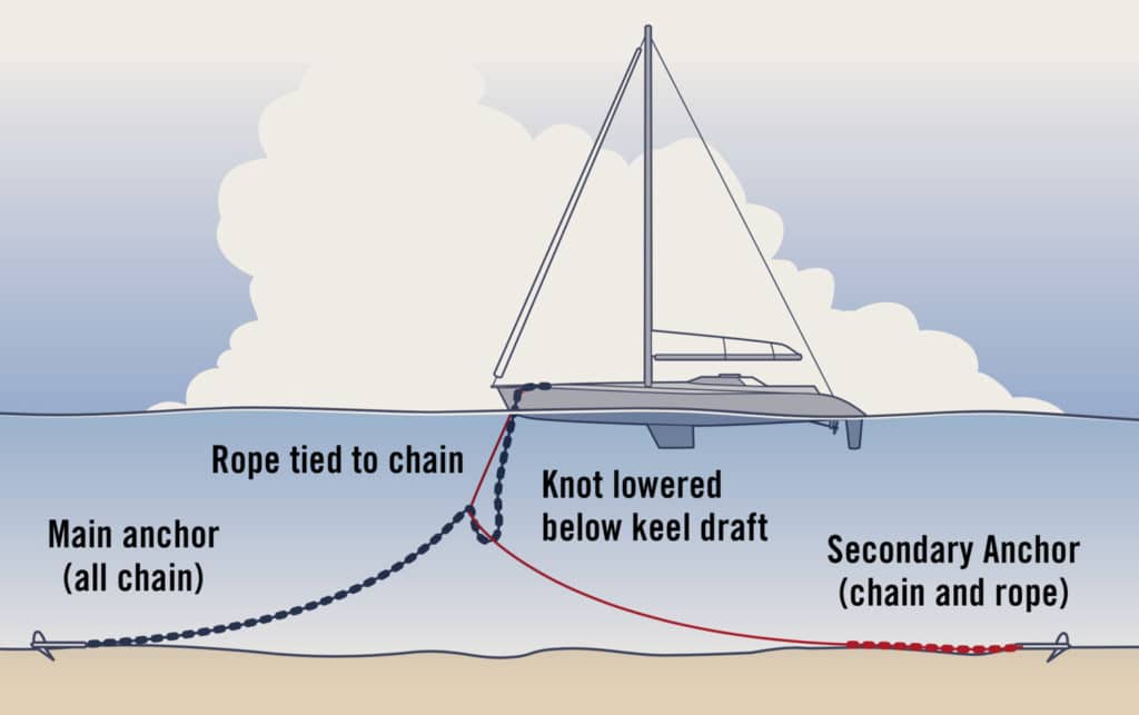
Bahamian Moor in Tight Spots or Currents
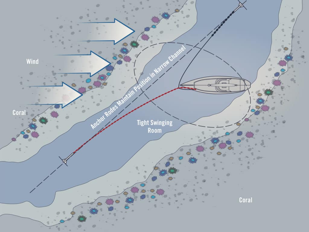
Once you have reached the protected side of the lagoon, the quest for a large, sandy spot to drop the hook starts. It helps to scrutinize high-resolution satellite images beforehand. On Pitufa, our 41-foot aluminum sloop, we strictly avoid damaging corals, so the search for an anchoring spot can take a while. As a rule of thumb, bommies are less numerous on the shallow reef shelf (3 to 15 feet) than in deeper (15 to 40 feet) areas—additionally, if you anchor in the shallows, you have the benefit of floating in minty swimming-pool colors.
Because many lagoons are not charted, it is necessary to sound the area cautiously. Slowly maneuvering in the shallow water is rather exciting in the beginning, but you quickly learn to distinguish the different shades of the water and to read them as depths: turquoise over sand, and green to brown over coral. Don’t forget to take a look at the tide table before deciding on an anchoring spot.
If the sandy patch is not big enough to swing around with sufficient scope, environment-conscious cruisers float the chain using fenders or buoys. Sadly, we often had to watch neighbors fouling their chain in coral, either due to a lack of awareness, experience or adequate anchoring gear. Questioned about their motives, the reply is usually an indifferent shrug or paltry excuses. Recently, some old salts shocked us by stating their usual method of anchoring was to drag the anchor until it gets stuck in coral, as their Delta anchor would not set in sand. The results of such behavior are desolate rubble fields underneath popular anchorages, and anchoring bans, which then keep out eco-friendly cruisers as well. A fouled chain is not only an environmental issue, but it can also endanger the safety of the boat when the anchor is stuck in an emergency situation.
Of course, it is true that floats partly nullify the weight advantage of a chain. It is therefore important to have as much scope as possible before hooking in the first fender, and to properly set the anchor. In locations with currents—for example, in narrow lagoon channels—a floated chain can lead to problems. Especially in combination with gusts, the fenders can float next to the hull (or even worse, one to port and one to starboard), and the chain can start scraping the keel. In such conditions, a Bahamian moor is a safer, if a somewhat more complicated and laborious alternative.
Keep Moving
No matter how pretty the anchorage, it is always a good idea to keep an eye on the weather and be prepared for changes in wind direction. On Pitufa, we get weather forecasts and GRIB files each morning, sometimes via our 3G data modem but mostly via Pactor modem on the SSB radio. Thus we can plan ahead for the next few days. When will the current anchorage become uncomfortable? Where can protection be found after the wind shift? When is it wise to start moving?
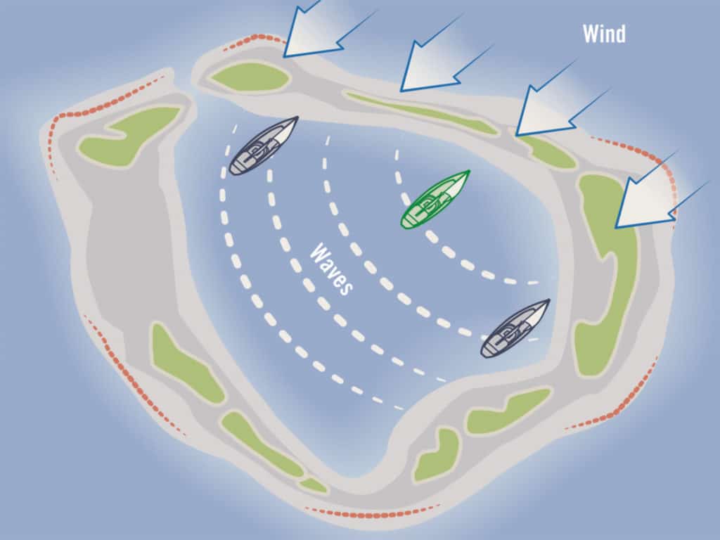
Why Are Waves Always Abeam?
There’s no one right answer. If you wait until the wind has shifted, you will have to motor against the wind or tack all the way. If you trust in the weather forecast and move in anticipation, you will have a nice sail across the lagoon, but there will still be waves once you reach the other side, and the forecasted shift might never happen.
In French Polynesia, we often meet cruisers who are proud of having done many of the Tuamotus in a short time. Those who rush through the atoll chain will be able to look back at thrilling (or nerve-racking) passes, but they will not have really experienced an atoll. Patient cruisers who explore all corners of a lagoon during wind shifts are rewarded with picture-perfect remote motus with bird colonies and pristine coral reefs. Only crews who spend a longer time at anchor off a village have the chance to make friends with the locals and get an insight into the culture, daily life, and challenges of communities on such remote and often quite barren islands. The pace of life there is slow—so relax, take your time, and live the dream.

